- Posted by: Whittle Consulting
- On November 25, 2020
- 0 Comments
Changed circumstances create new opportunities. Due to COVID, Whittle Consulting has trailed drone technology with significant success. In this article we discuss the exciting new development.

COVID has been the ultimate business disrupter. Pre-COVID, the Whittle Consulting business model was heavily reliant upon international travel. The CEO of Whittle Consulting, Gerald Whittle, was a 200-day a year international business traveler. Management of Whittle Consulting projects was traditionally conducted face-to-face with onsite mine visits. This required Whittle personnel to frequently travel to some of the geographically remotest mines in the world.
The impact of COVID
In March 2020, COVID hit. Almost overnight international travel ceased. To keep operations COVID-free, mines banned any external personnel from entry and arranged for management to work remotely from the safety of their homes. As a result, Whittle Consulting had to quickly come up with an alternative to onsite mine visits.
Faced with this new reality, Whittle Consulting in collaboration with SMG Consultants (SMGC) increased their use of drone technology. Drones had already been used for some operational intelligence-gathering, but their ability to be used for site visits was quickly recognised and harnessed.
How are drones used?
With the help of drone technology, Whittle and SMGC created automated mine flight plans which were uploaded to the drone. A pilot is contracted to fly the drone, as per the specified flight path, generally in a back and forth sequential manner. The first flights are vertical photos with video footage taken later. Depending on the size of the site, multiple flights may be required. Flight paths with either a horizontal or vertical elevation can also be run.
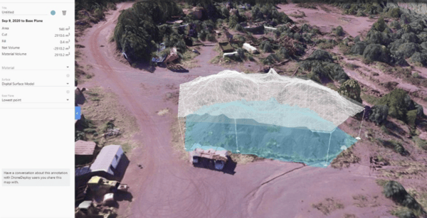
Using the drone, elevations are measured to create elevation and topographical models. Detailed geographical data is collected with crystal-clear detail. This enables the development of high-quality geological maps. Operational progress can also be followed, as well as the analysis of onsite mine infrastructure, to assess the condition and viability of plant processing equipment.
Using Google Earth as a reference point, GPS positioning can be calculated to an accuracy within a few metres. If the situation allows for the surveying of 4 large checkerboard markers, this geographical accuracy can be even further improved to within centimetres.
What sort of drone is required?
In most cases, consumer-level drones, which were owned and operated by local pilots, have been utilised. At a cost of around USD$1,300, they have advantages over more expensive drones, as parts and batteries are cheaper and more readily accessible. The major consideration is in matching the battery capacity to the flight plan. With most drone batteries having only a 20 to 30-minute life, it is important that the drone pilot is as close to the mine as possible and that a plentiful supply of replacement batteries is at hand.
How is the information processed?
Due to the need to access stable broadband, all flight information and imagery is downloaded later at a nearby hotel or township – usually overnight. Once the information gathering phase is complete, all of the imagery and information that has been captured is then imported into a software program that generates a 3D conceptual site model.
Should it be required, the information is downloaded into mine software. It is then used to generate new pit shapes and to extrapolate the information required to conduct a range of mine optimisation activities.
This information is then available for the Whittle team and their clients to analyse and review together virtually. This is an efficient and powerful way of bringing together all of the Whittle Consulting technical and professional expertise to the task. The Whittle team and various members of the client’s project team, including any associates and consultants, are often located in several different countries. All parties can now work together via Zoom or other technology, to bring the power of their combined knowledge and experience to the operation. Should it be required, further drone flights can then be conducted to capture any additional information required.
Where to from here?
It is only early days for the use of drone technology by Whittle Consulting. However, the payback is already significant and the potential is only beginning to be realised.
Drone technology has been a game-changer in the ease, speed, quality and cost efficiency of obtaining detailed, high-definition, 3-D mine site visuals. At the beginning of 2020, Whittle personnel would have travelled to remote locations to look at these mine sites, with all the inherent safety and health risks.
Now, thanks to drone technology this type of business travel is a thing of the past. Whittle personnel now conduct a superior level of analysis and review from the comfort and safety of their homes and offices all over the world. As the technology progresses, the advantages will only increase. Access to real time footage will be the next major stepping stone for Whittle Consulting in the pivot to drone technology.
Due to COVID, drone technology has altered forever the way that Whittle Consulting conducts their business. This is only the beginning of an exciting new phase in the world of mining optimisation.
Click here to watch a short 2 minute video showcasing the use of drone technology for a virtual mine site visit.
The above news piece is a story from the Whittle LIVE BOOK. To read other interesting stories including the history of Whittle Consulting & Whittle Programming, CLICK HERE to access the Live Book.
If you have any questions about the work that Whittle Consulting does, please contact us.